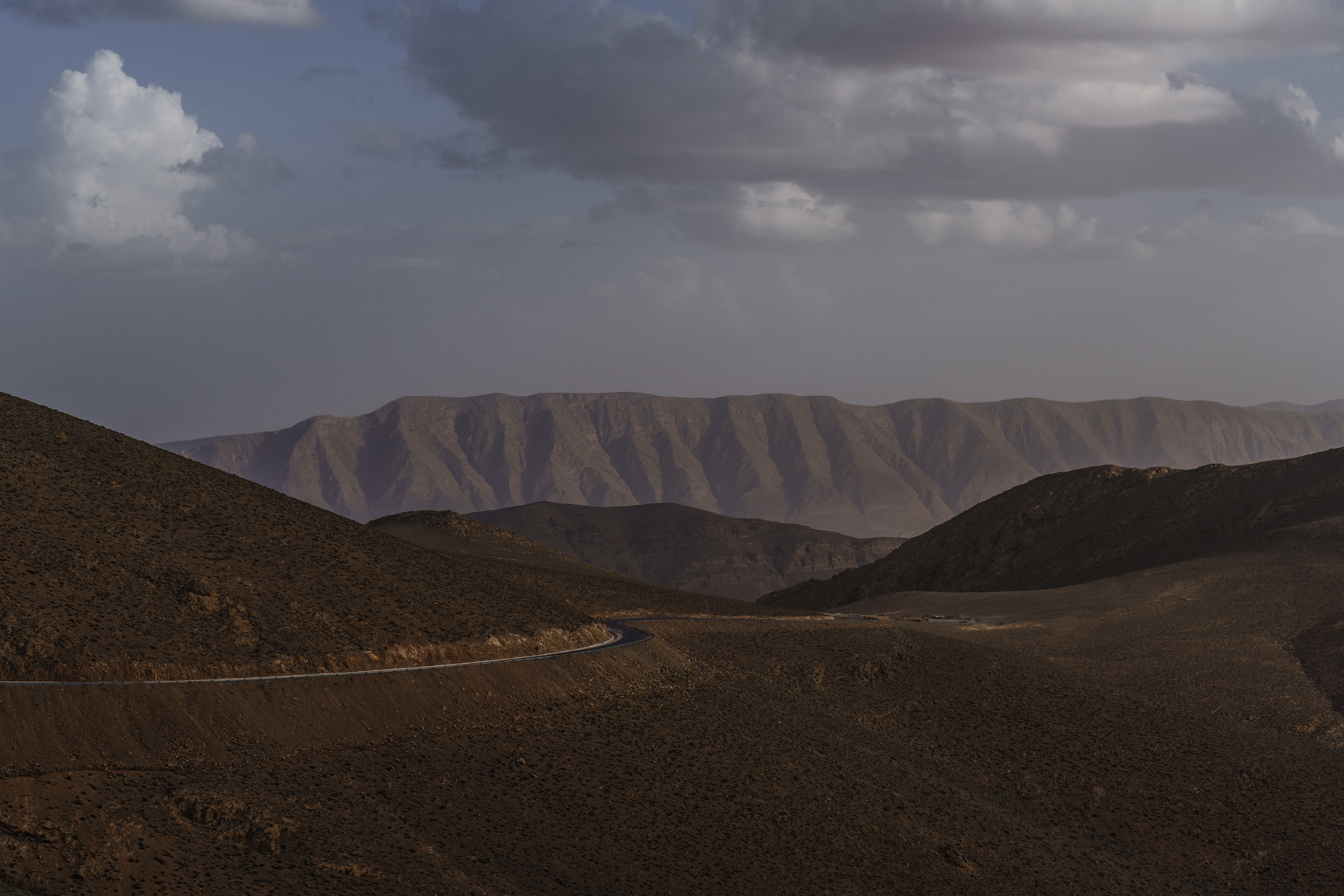
I was looking forward to being in the mountains again as we approached Tinghir. The landscape around us started to change, with some of the earlier scenery fading into the background. Eventually, we arrived at the famous Todra Gorges.


There, we met Ahmed, a professional climber who offers climbing tours in the Todra. We also ran into three climbers from the Netherlands. The place was filled with tourists, but it was beautiful. We took a break, enjoyed some snacks, and continued our journey.
Just around the next corner, after climbing 200 meters, we stopped to take a photo of the oasis below. That’s when we met the first cyclists we’ve seen in Morocco in two months—Guillaume and Manon. They’re travelling through Morocco for a few weeks before heading back to France.


We kept cycling, and after a few days of crowded, touristy spots, we finally found ourselves on a quiet road, free from kids, adults, and cars. Our plan was to reach Agoudal, but we accidentally took a wrong turn that led us to a dam, costing us around 20 extra kilometres. So, we decided to head to Tamtattouchte instead.


We arrived just before sunset and found a cheap place to stay, thanks to Ibrahim, a kind man who helped us out. He told us all about his life, his family, and his 10 children whom he needs to support.
hat night, we enjoyed a delicious Tagin and peaceful sleep in the mountains, and the weather is starting to get cooler again.

We divided the route into two stages. First, we aimed to reach Agoudal (climbing 1500m) and then continue to the mountain pass we wanted to cross into Msmir. There’s a new, good road to Msmir that would save us two days and 2000m of climbing, but we decided to take the 3000m mountain pass after hearing so much about how beautiful this route is.

There’s a lot of information about how difficult the mountain pass is—you need a 4×4, and the road is still under construction. Along the way, we met two cyclists from New Zealand. The scenery was incredible, and we were enjoying the road immensely. When we arrived after the 600m climb up to Agoudal, we wanted to visit a salt mine, but we couldn’t find the road, and no one was willing to show us the way. The village was busy with a wedding, so after two hours of searching, we gave up on finding the salt mine and decided to continue since it was already late.

Finding a camping spot was challenging, as the roadside areas were full of large rocks. We asked a few people if we could camp nearby, but no one agreed. So we decided to continue on to Agdal and tackle the next 600m climb.
We saw some workers on the road are pretty high and do some jokes that I didn’t understood . We reached the highest point of the day, 2850m, right at sunset and were relieved to find some flat spots where we could pitch our tent.
From a distance, Ali saw us and invited us to set up our tent near his car. He was a security guard for the water area that the nomads use in summer. We had a wonderful conversation with Ali, he prepared some beans in his funny pressure pot closing the steam with an apple. we enjoyed a cold but restful night’s sleep.
We said goodbye to Ali after we took breakfast together. and ascended toward Agoudal. We stopped there for second breakfast and a good espresso, then continued to visit a famous cave in the area. To reach the cave, we had to hike for a few hours (more on that in the next post).
On the way to Agdal, we saw a real nomad, just as Ali had described. The nomads are now moving to warmer areas because winter is approaching, but in summer, they live here at over 2800 meters. And the area could be unreachable for a few months if it’s snowing.
The scenery is breathtaking, and the traffic is very light—only about one car every few hours. All the nomad houses we passed were empty, whole non-existing villages on the maps.

Between Agoudal and the mountain pass to Msemir lies Akhiam Cave, a remarkable limestone formation that showcases the unique geology of the Atlas Mountains.
The Grotte Akhiam in the High Atlas Mountains is estimated to be millions of years old, its formation dating back to the tectonic shifts that created the Atlas range. Like many limestone caves, Akhiam was likely formed through the slow erosion of rock by water, as rain and underground streams dissolved the limestone over time, carving out caverns, tunnels, and intricate formations.
Although there isn’t much recorded history specific to Grotte Akhiam, caves in this region have traditionally been used by local Berber communities for shelter and storage, especially given the harsh climate.

To reach the cave, we hiked for a few hours, completely alone on the trail. There are supposed to be two waterfalls along the route, but both were unfortunately dry. We left our bikes at a small, unfinished guesthouse owned by Ali, who, with his warm smile, kindly agreed to watch over them until we returned.
The weather forecast warned of an afternoon storm, so we remained alert. Despite this, it was one of the most enjoyable hikes we’ve done. When we returned to pick up our bikes, we found that Ali had already prepared a tagine for us. As we enjoyed the meal, two Swiss campervans arrived at the cave area. (We knew later that they have to be rescued from the storm that flooded the whole area)

We thanked Ali and his friend for their hospitality and said goodbye, ready to continue our journey.


We could take the new road from Tinghir to Msimir, avoiding the mountain pass. However, we knew that the climb would be worth it.The extreme silence heightened my fear as I saw how quickly the weather changed from a clear sky to dark clouds approaching the area. It started to rain, and with no shelter available, we cycled on as the rain grew heavier and the thunder became more intense.After a few kilometers, we found a small room measuring 2×3 meters, with no windows; it was an unstable shelter for animals. It turned out to be the perfect refuge as water began to collect, forming large floods.After two hours, the rain stopped, but it was getting late, so we set up our tent inside the room and tried to rest. Suddenly, Sandra experienced extreme pain in her stomach and throughout her body. I used my Garmin to measure her blood oxygen saturation, and it registered at 73%.There was no telephone network, and the next village, Agoudal, was 12 kilometers away. I knew that I would have to carry her that distance if her saturation dropped below 70%.I couldn’t sleep that night, and early the next morning, I took my bike and ascended to the nearest guesthouse to find a car to take Sandra to the hospital. It was likely she was suffering from altitude sickness.We took three days off in Agoudal and planned to attempt the mountain pass again after resting.


Leave a Reply